- Price: 1$
- Size Facebook: 1702 x 630 px
- Size Twitter: 1500 x 500 px
- Size LinkedIn: 1128 x 191 px
More Facebook, Twitter and LinkedIn Cover Photos
Cover photo info
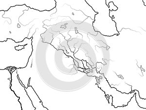
- Photo title: World Map of MESOPOTAMIA: Šumer, Akkad, Babylonia, Assyria, Tigris & Euphrates. Geographic historic chart of Ancient Persian Gulf.
- Author: Odyssei
- Cover photo description:
- World Map of The TIGRIS & EUPHRATES Valley: Mesopotamia, Assyria, Babylonia, Šumer (Sennaar, Canaan), Akkad, Elam, Persis, Atropatene, Parthia, Média kingdoms. Geographic historical chart of Ancient Persian Gulf coastline (c.5000 B.C.)
- Image ID:154522708
- Views:0
- Downloads:3
Keywords for Facebook, Twitter and LinkedIn timeline photos
adventure
akkad
ancient
arabia
archeology
armenia
assyria
atlas
atropatene
babylon
babylonia
canaan
cartography
chart
civilization
coastline
countries
east
egypt
egyptology
elam
euphrates
fertile
geographic
geography
gulf
historical
history
iraq
jordania
kingdoms
land
landmark
levant
location
map
media
mesopotamia
middle
navigation
nile
palestine
parthia
persia
persian
persis
phoenicia
rivers
sea
semite
sennaar
sumer
syria
territories
tigris
tourism
travel
valley
world
umer
média
historic
euphrates
gulf


