- Price: 1$
- Size Facebook: 1702 x 630 px
- Size Twitter: 1500 x 500 px
- Size LinkedIn: 1128 x 191 px
More Facebook, Twitter and LinkedIn Cover Photos
Cover photo info
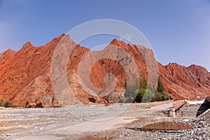
- Photo title: View of red mountains of Oytagh Canyon, along the Karakoram Highway from Kashgar to Tashkurgan, Xinjiang Uyghur Autonomous Region
- Author: positivesoundvision
- Cover photo description:
- The Karakoram Highway is the highest paved international road in the world. Known by its initials KKH also known as N-35 or National Highway 35 or the China-Pakistan Friendship Highway, the 1,300 km national highway follows the old Silk Road route from China to Pakistan. It currently extends from Hasan Abdal in the Punjab province of Pakistan to the Khunjerab Pass in Pakistan Occupied Kashmir, where it crosses into China and becomes China National Highway 314.
- Image ID:225716556
- Views:0
- Downloads:0
Keywords for Facebook, Twitter and LinkedIn timeline photos
abdal
autonomous
canyon
china
friendship
hasan
highest
highway
international
karakoram
kashgar
khunjerab
kkh
mountain
national
old
oytagh
pakistan
pamir
pass
paved
province
punjab
red
region
road
route
silk
tashkurgan
uighur
uyghur
world
xinjiang


