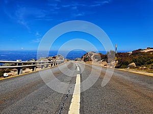
- Stock Photography: ROAD IN SERRA DA ESTRELA PORTUGAL by Pagmarques
- Price: 1$
- Size Facebook: 1702 x 630 px
- Size Twitter: 1500 x 500 px
- Size LinkedIn: 1128 x 191 px
More Facebook, Twitter and LinkedIn Cover Photos
Cover photo info
- Photo title: Road in Serra da Estrela Portugal
- Author: Pagmarques
- Cover photo description:
- Serra da Estrela Portuguese pronunciation: [ˈsÉ›ÊÉ Ã°É É¨ÊƒËˆtɾelÉ], `Star Mountain Range` is the highest mountain range in Continental Portugal. Together with the Serra da Lousã it is the westernmost constituent range of the Sistema Central and also one of the highest in the system. It includes mainland Portugal`s highest point at 1,993 metres 6,539 feet above mean sea level although the summit of Mount Pico in the Portuguese Azores islands is higher. This point is not a distinctive mountain summit, but rather the highest point in a plateau, being known as Torre `Tower` in English. Torre is an unusual summit in that it is accessible by a paved road. The peak has a topographic prominence of 1,204 m 3,950 ft and its parent peak is Pico Almanzor, in Spain.[1] The mountain range, situated between the municipalities of Seia, Manteigas, Gouveia, Guarda and Covilhã, is about 100 kilometres 60 miles long and is 30 km 19 mi across at its widest point. It is formed from a huge granite ridge that once formed the southern frontier of the country.
- Image ID:245811213
- Views:0
- Downloads:0
Keywords for Facebook, Twitter and LinkedIn timeline photos
aldeia
antiga
certos
chamado
cobertas
comunitária
conservam
constituída
construções
costumes
cultura
das
dedica
dos
doutor
escarpas
especial
esta
existência
fluvial
inferno
latadas
maiores
milho
num
para
pastorícia
pedro
pequenas
poente
população
por
portal
portugal
praia
profundo
próximo
rebanhos
regadio
relevo
rodeada
romão
ruas
situa
sul
termas
vale
vida
xisto


