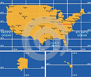
- Stock Photography: USA MAP INFOGRAPHIC DIAGRAM WITH ALL SURROUNDING OCEANS MAIN CITIES by Udaix4
- Price: 1$
- Size Facebook: 1702 x 630 px
- Size Twitter: 1500 x 500 px
- Size LinkedIn: 1128 x 191 px
More Facebook, Twitter and LinkedIn Cover Photos
Cover photo info
- Photo title: USA map infographic diagram with all surrounding oceans main cities
- Author: Udaix4
- Cover photo description:
- USA map infographic diagram with all surrounding oceans and main cities. longitude and latitude lines. united states of America border. US capital and American islands territory vector. illustration for geography education and atlas world
- Image ID:246839035
- Views:0
- Downloads:0
Keywords for Facebook, Twitter and LinkedIn timeline photos
alaska
america
american
angeles
atlanta
atlantic
atlas
border
boston
capital
chicago
cities
city
detroit
diagram
eagle
education
flag
francisco
geography
globe
gulf
hawaii
houston
illustration
infographic
island
las
latitude
line
longitude
los
main
map
mexico
miami
new
ocean
oklahoma
orlando
orleans
pacific
san
seattle
state
territory
united
usa
vector
vegas
world
york


