- Price: 1$
- Size Facebook: 1702 x 630 px
- Size Twitter: 1500 x 500 px
- Size LinkedIn: 1128 x 191 px
More Facebook, Twitter and LinkedIn Cover Photos
Cover photo info
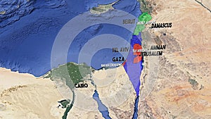
- Photo title: A 3D satellite animated map highlighting Lebanon in green, Palestinian Territories in Red, and Israel in Blue.
- Author: Alichehade5
- Cover photo description:
- A 3D satellite animated map highlighting Lebanon in green, Palestinian Territories (Gaza, West Bank) in Red, and Israel in Blue. Major cities airports labeled. Cairo, Damascus Amman Beirut Tel Aviv
- Image ID:294639581
- Views:0
- Downloads:0
Keywords for Facebook, Twitter and LinkedIn timeline photos
middle
east
map
geography
satellite
beirut
jerusalem
damascus
cairo
tel
aviv
gaza
amman
rafah
airport
travel
borders
terrain
ocean
cities
landmarks
earth
aerial
view
topography
countries
waters
mediterranean
conflict
desert
coast
continental
israel
jordan
lebanon
syria
palestine
egypt
education
research
guide
poster
background
atlas
navigation
history
region
cultures
boundaries
sea
sattelite
animated
3d
labels
amman


