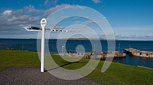
- Stock Photography: JOHN 'O GROATS NEW SIGNPOST AND HARBOUR, CAITHNESS, SCOTLAND, UK by Loinshoes
- Price: 1$
- Size Facebook: 1702 x 630 px
- Size Twitter: 1500 x 500 px
- Size LinkedIn: 1128 x 191 px
More Facebook, Twitter and LinkedIn Cover Photos
Cover photo info
- Photo title: John 'o Groats New Signpost and Harbour, Caithness, Scotland, UK
- Author: Loinshoes
- Cover photo description:
- John 'O Groats New Signpost and Harbour, Caithness, Scotland, UK. John o'Groats NE of the village of Canisbay, Caithness, in the far north of Scotland. John o' Groats lies on Great Britain's northeastern tip, and is popular with tourists as one end of the longest distance between two inhabited British points on the mainland, with Land's End in Cornwall lying 876 miles (1,410 km) to the southwest. It is not the most northerly point on the island of Britain (nearby Dunnet Head is farther north). John o' Groats is 690 miles (1,110 km) from London, 280 miles (450 km) from Edinburgh, 6 miles (10 km) from the Orkney Isles and 2,200 miles (3,500 km) from the North Pole. It is 4.25 miles (6.8 km) from the uninhabited Island of Stroma. The settlement takes its name from Jan de Groot, a Dutchman who once plied a ferry from the Scottish mainland to Orkney, which had recently been acquired from Norway by King James IV. Local legend has that the "o' Groats" refers to John's charge of one groat for use of his ferry, but it actually derives from the Dutch de groot, meaning "the large". People from John o' Groats are known as "Groaters". The name John o' Groats has a particular resonance because it is often used as a starting or ending point for cycles, walks and charitable events to and from Land's End (at the extreme south-western
- Image ID:34059887
- Views:307
- Downloads:2
Keywords for Facebook, Twitter and LinkedIn timeline photos
architecture
backgroud
background
caithness
grass
grouts
harbour
john
landmark
scotland
sea
signpost
white
landscape
seascape
northeast
stoma
wall
walls
canisbay
clouds
cloud
sky
blue
john
o
groats
de
groot
groaters
quay
port
uk
ferry
slopes
hills
hill
north
sea
pentland
firth


