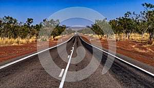
- Stock Photography: VICTORIA HIGHWAY KIMBERLEYS by Mauriehill
- Price: 1$
- Size Facebook: 1702 x 630 px
- Size Twitter: 1500 x 500 px
- Size LinkedIn: 1128 x 191 px
More Facebook, Twitter and LinkedIn Cover Photos
Cover photo info
- Photo title: Victoria Highway Kimberleys
- Author: Mauriehill
- Cover photo description:
- In northern Western Australia population is sparse, no more so than the remarkable Kimberleys, where roads are rarer. The Kimberley consists of the ancient, steep-sided mountain ranges of northwestern Australia cut through with sandstone and limestone gorges and steep ridges, from which the extreme monsoonal climate has removed much of the soil. The southern end of the Kimberley beyond the Dampier Peninsula is flatter with dry tropical grassland and is used for cattle ranching. In parts of the Kimberley, such as the valleys of the Ord and Fitzroy Rivers in the south, the soils are relatively usable cracking clays, whilst elsewhere they are lateritic Orthents. Although none of the mountains reach even 1,000 metres 3,281 ft, there is so much steep land as to make much of the region difficult to traverse, especially during the wet season, when even sealed roads are often flooded. The coast is typically steep cliffs in the north but flatter in the south, all subject to high tides. The Kimberley was one of the earliest settled parts of Australia, with the first arrivals landing about 41,000 years ago
- Image ID:158021158
- Views:0
- Downloads:0
Keywords for Facebook, Twitter and LinkedIn timeline photos
41000
ago
ancient
argyle
arrivals
australia
australiann
broome
cattle
climate
consists
cut
dampier
dry
earliest
end
extreme
first
fitzroy
flatter
gibb
gorges
grassland
has
highway
kimberley
kimberleys
lake
landing
limestone
monsoonal
mountain
much
northern
northwestern
one
ord
parts
peninsula
ranching
ranges
removed
ridges
river
rivers
road
sandstone
settled
soil
southern
steep
steepsided
such
tropical
used
valleys
victoria
was
western
which
years


